Macaulay is a precinct that historically has served as an industrial and warehousing hub. It is now being transitioned into a mixed-use, inner-city neighbourhood that is highly liveable and prosperous.
Our discussion paper outlines how we are refreshing the 2012 structure plan (PDF 47.11 MB) vision for Macaulay.
Your feedback will inform the draft Macaulay Structure Plan Refresh, which will be presented for community feedback in 2020.
Read the discussion paper
Built form: refers to the function, shape and configuration of buildings and their relationship to streets and open spaces.
Community infrastructure: refers to public places and spaces that accommodate community facilities and services and support individuals, families and groups to meet their social needs, maximise their potential and enhance community well-being.
Development application: a formal application for development of a site. The application is usually made to local council and consists of an application form, supporting reports and plans of the proposed building or works.
Floor Area Ratio: the ratio between the allowable total floor area developed on a site to the site area. A Floor Area Ratio of 5:1 would permit 5,000 square metres of floor area to be developed on a 1,000 square metre site.
Land use zones: the planning scheme zones land for different uses and sets out each zones purpose and set of requirements.
Mixed use zone: provides for a range of residential, commercial, industrial and other uses.
Open space: the publicly-owned land that is set aside primarily for recreation, nature conservation, passive outdoor enjoyment and public gatherings. This includes public parks, gardens, reserves, waterways, forecourts and squares.
Overlay: the planning scheme maps zoning and overlays of land. Not all land has an overlay on it and only applies if there is a special feature of the land. For example a heritage building or a flood risk.
Permeability: describes the extent to which the urban form permits or restricts the movement of people of vehicles in different directions.
Planning controls: include zones, overlays, and particular provisions that are contained within the planning scheme.
Planning scheme: the Victorian Government and local councils develop the planning scheme to set out rules about the use and development of land.
Planning scheme amendment: changes to the planning scheme are called amendments.
Planning scheme amendment C190: implements the Arden-Macaulay Structure Plan’s Stage 1 land use and development recommendations by making changes to the planning scheme.
Public housing: is a form of long-term rental social housing for people on the low incomes that are most in need. Public housing is owned and managed by the Victorian Government.
Public realm: external urban spaces that are publicly accessible and belong to everyone. This includes streets, squares, parks, green spaces and other outdoor spaces.
Social housing: is short and long-term rental housing that is owned and run by the Victorian Government or not-for profit agencies.
Structure plan: is a document with a shared vision for an area and identifies the type and scope of change projected within an area over time.
Urban renewal areas: are areas to be redeveloped from industrial or low-intensity land uses to mixed-use precincts. Urban renewal areas in the municipality include Fishermans Bend, Arden and Macaulay.
The need for an updated structure plan
The Minister for Planning has requested that we review the built form controls and has identified a number of improvements that could be made.
The Victorian Planning Authority and the City of Melbourne are leading planning for Arden.
The City of Melbourne will undertake planning for Macaulay.
The Metro Tunnel is due to open in 2025. While the project will deliver a direct benefit for Arden, it will also improve transport in Macaulay.
The Victorian Government has revised forecasts for Macaulay, with an estimated 10,000 residents and 9,500 workers by 2051.
With extreme rainfall expected, an integrated approach to water management is required to mitigate the impacts of flooding.

A detailed contributions plan identifying infrastructure requirements for the increased population of the area is being prepared.
Refreshing the structure plan
The 2012 structure plan contained six themes:
- Activities and land use
- Urban structure and built form
- Transport and access
- Public realm
- Community infrastructure
- Sustainable infrastructure.
We are proposing to consolidate and simplify the six theme based visions from the 2012 structure plan into a single vision for Macaulay.
Sustainable infrastructure is no longer a stand-alone theme, as environmental sustainability is embedded within all themes.
Flooding is now included as a separate theme, which reflects the increasing recognition that flooding is a key issue for the area.
Proposed vision
Macaulay will transition into a mixed use, mid-rise neighbourhood with a distinct inner urban character. New development will be high quality and deliver amenity for residents, workers and visitors.
Improvements to public transport services, walking and cycling will be prioritised to support sustainable modes of travel.
Greening of streets, enhancing the Moonee Ponds Creek and the delivery of new open spaces will provide connections and a network of local places.
Public and private investment will deliver community infrastructure to meet the needs of a growing and diverse neighbourhood.
Macaulay will adopt innovative solutions to climate change adaptation and mitigation.
Theme 1.1. Activities and land use: Zoning

Land in Arden and Macaulay is underutilised and should be rezoned to facilitate change.

In 2017 Planning Scheme Amendment C190 introduced the Mixed Use Zone and Commercial Zones.

Current applications are not delivering a genuine mix of use, with the majority of new developments being residential.
How we are proposing to respond:
Ensure land use zones support the future vision for Macaulay and deliver a true mixed use neighbourhood.
A mix of different uses helps make a place more interesting and lively at different times of day and days of the week. Having a range of shops, services and jobs available within a short distance of homes encourages more sustainable transport choices and improves people’s quality of life.
Theme 1.2. Activities and land use: Affordable housing
Arden and Macaulay should be contributing towards the provision of affordable housing.
There is a clear and significant need for affordable housing in the municipality.
One completed development and one development with planning approval are providing affordable housing options in Macaulay.
How we are proposing to respond:
Urban renewal areas such as Macaulay provide an opportunity to take a proactive role in providing accessible, affordable and diverse homes. This would make the level of amenity and access to services available to a greater range of people.
In preparing a refreshed structure plan we will:
- assess the current target for affordable housing in Macaulay
- include mechanisms in the refreshed structure plan to deliver affordable housing.
Theme 2. Urban structure and built form
The plan introduced a series of strategies to deliver high quality urban design.
The Minister for Planning identified a number of improvements that could be made to the current built form controls introduced through Amendment C190.
The current controls are based on building heights and setbacks rather than setting a specific amount of development that can occur on a site.
How we are proposing to respond:
We will review the current controls and develop new built form controls that support high quality urban design outcomes for Macaulay.
This includes:
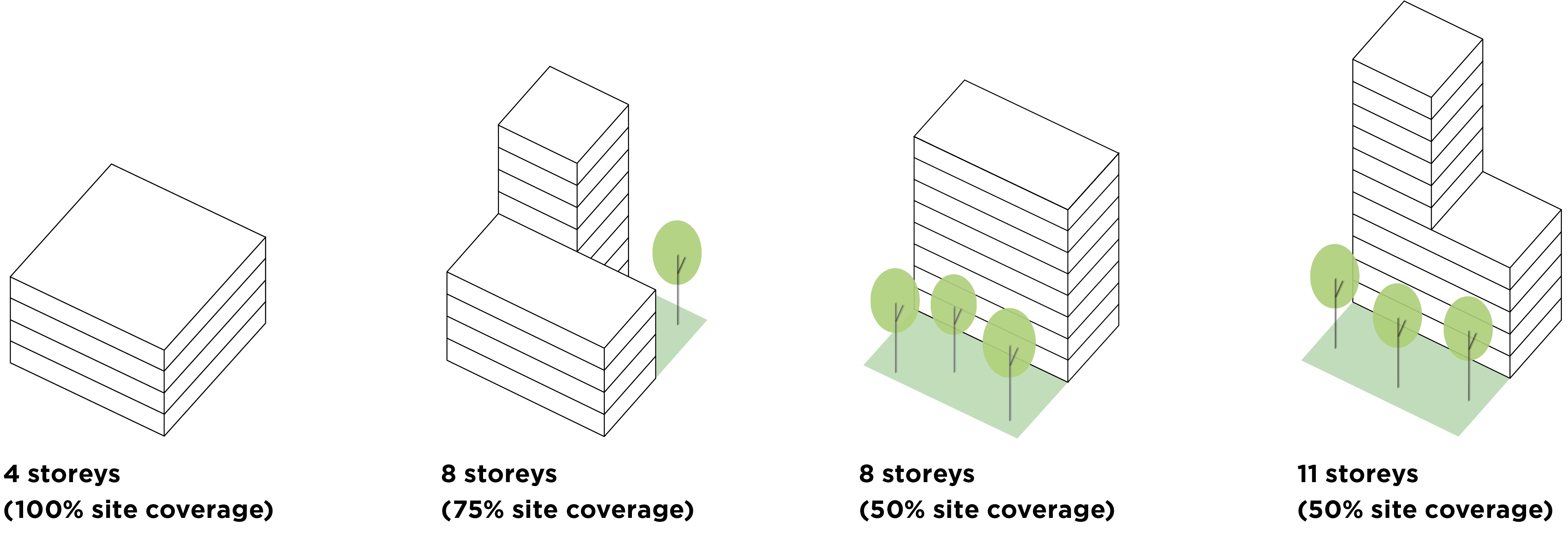
- developing new density controls through floor area ratios – see diagram below
- improving built form controls
- ensuring new buildings are sustainable.
These diagrams show an example of a floor area ratio of 4:1. Each building has a total floor area four times the size of the site itself, but with variation in design.
Theme 3. Transport and access
The need for high quality public transport infrastructure. Streets will be designed to prioritse pedestrians, cyclists and public transport.
The Metro Tunnel is under construction and due to open in 2025.
Macaulay benefits from close proximity to central city, but could better support active and sustainable transport modes.
How we are proposing to respond:
Progress measures which improve the safety, comfort, attractiveness and convenience of walking, cycling or taking public transport.
We'll do this by:
- supporting increased use of active transport (walking and cycling)
- improving public transport
- reducing use of private vehicles.
Theme 4. Public realm
The plan identified how Macaulay's urban structure, built form, open spaces and transport network can improve the quality of the public realm.
Updates and developments to the:
Public Open Space Contribution
There are few open spaces and many large land holdings in Macaulay, making the current public realm hostile for pedestrians with limited connectivity.
How we are proposing to respond:
Macaulay's streets and open spaces will be great places for people, celebrating water in the landscape and helping to restore local ecosystems.
We'll work towards delivering:
- a connected street network
- a revitalised Moonee Ponds Creek
- a diverse network of new open spaces.
Theme 5. Community infrastructure
Ways to support the community by upgrading facilities, establishing a new community centre, and selecting a suitable location for a new school.
An interim Development Contributions Plan Overlay is in place to collect funds for infrastructure.
The majority of community infrastructure is located in three facilities clustered around Melrose Street and Buncle Street in North Melbourne.
How we are proposing to respond:
Alongside other agencies we are planning for Macaulay's future community infrastructure needs including work on the redevelopment of the North Melbourne Community Centre.
Theme 6. Flooding
The plan identified the need for detailed investigations to inform mitigation strategies.
The Municipal Integrated Water Management Plan and Moonee Ponds Strategic Opportunities Plan set out approaches to manage the impacts of flooding.
Flooding is caused by trapped stormwater, local pump stations failing to keep up, runoff from upstream catchments and a lack of permeable surfaces.
How we are proposing to respond:
Water can be celebrated as a feature of Macaulay. This can be achieved by incorporating stormwater treatment and reuse into buildings, streets and open space.
Next steps
Feedback we gather will be used to inform the refreshed Macaulay Structure Plan, which will be released for community consultation in early 2020.
A community consultation summary will also be available in early 2020.


