


North
The Collector
As Melbourne’s population grows, Moonee Ponds Creek has the potential to become an attractive and connected playground for the rapidly growing inner city, as well as a vital flood management and biodiversity asset.
The entire Moonee Ponds Creek runs for 25km from the Local Government area of Hume in the north, through established middle ring suburbs and to the southern reaches within the City of Melbourne. Here it runs through established suburbs of Kensington, North Melbourne and West Melbourne, and alongside urban renewal areas of Arden, Macaulay, Dynon and E-Gate.
The draft Strategic Opportunities Plan includes an overarching vision for the future of this neglected creek, along with six goals and 31 proposed creek improvement opportunities that work to achieve this vision.
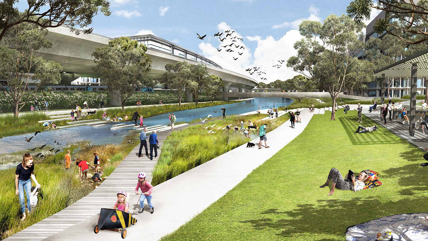
Artistic impression of the Macaulay Terrace on a sunny afternoon and during a major rain event.

Before European settlement in 1835, Moonee Ponds Creek was an integral part of the ‘temperate Kakadu’ that was Melbourne.
The Creek – which was a chain of ponds during drier months and a flood plain during heavy rains – was a travel route and water and food source for the Wurundjeri tribe of the Woiwurrung language group. It also fed into a picturesque saltwater lake near to what is now Southern Cross Station.
In the decades after 1835, everything changed.
The Creek’s cultural importance to local Aboriginal people was ignored. The saltwater lake was turned into a tip, then filled in. Meanwhile, for much of the next 150 years, Moonee Ponds Creek was treated as an industrial drain and transport corridor.
The draft Moonee Ponds Creek Strategic Opportunities Plan highlights the strategic opportunities along the creek between Brunswick Road and Docklands, building on the Chain of Ponds Masterplan developed by Moreland and Moonee Valley Councils to the north.
It will deliver on several Council strategies that have been informed by extensive community engagement over many years, including:
The final plan will be developed in collaboration with stakeholders in the Victorian Government, Victorian Planning Authority, other partner agencies and the community.
The City of Melbourne will continue to be an advocate for the transformation of the Moonee Ponds Creek corridor.
The Moonee Ponds Creek corridor has enormous potential but to realise that potential, three major challenges must be turned into opportunities:
The preparation of the draft Strategic Opportunities Plan has been supported by a comprehensive, background technical report prepared by McGregor Coxall and Wave Consulting.
This Report includes a review of the relevant City of Melbourne integrated water, land and open space policies.
It also includes a review of past technical work in the lower reaches of the Moonee Ponds Creek Corridor and Melbourne Water flood modelling that was undertaken in 2016.
The strategic opportunities proposed to improve the creek corridor and achieve the vision are identified over three maps. Some are focussed on specific opportunities at points along the waterway, while others are in multiple locations or intended for the whole corridor.
To achieve the strategic vision, the creek is divided into three areas:
1. North: The Collector
From Brunswick Road to Racecourse Road. What is now a concrete stormwater drain will be remediated –becoming a focal point for the local community and biodiversity.
2. Central: The Urban Connector
From Racecourse Road to Dynon Road. What is now an industrial area will become an area for mixed-use development. The area needs to be revitalised so it connects and supports the growing communities east and west of the Creek.
3. South: The Tidal Underpass
From Dynon Road to the Yarra. What is now an inaccessible, infrastructure dominated area will become a significant source of public open space in the City of Melbourne, with regionally significant benefits as well as benefits for local communities and the local environment.
The Collector
The Urban Connector
The Tidal Underpass
Acknowledgement of Traditional Owners
The City of Melbourne respectfully acknowledges the Traditional Owners of the land we govern, the Wurundjeri Woi-wurrung and Bunurong / Boon Wurrung peoples of the Kulin and pays respect to their Elders past and present. We acknowledge and honour the unbroken spiritual, cultural and political connection they have maintained to this unique place for more than 2000 generations.
We accept the invitation in the Uluru Statement from the Heart and are committed to walking together to build a better future.


