This pilot uses data and insights to explore how public spaces in our municipality can meet the needs and improve the experiences of the people who live, work and play in these spaces.
This pilot is located in the median strip in front of 313 Drummond Street, Carlton. It was one of three winning projects selected as pilots through the Reimagining the City challenge.
The details
This pilot looks at how we use data to inform and build public spaces that complements how people use different areas of the city, such as gathering and connecting with family and friends. By bringing together a multi-disciplinary team we can pilot and trial data informed designs and create public spaces that are more attractive and encourages people to stay, connect and enjoy the city.
What we are trying to understand
The objective of this pilot is to help us understand:
- if how we use our neighbourhoods has changed during the pandemic
- how our public spaces could adapt to accommodate the new needs of our community, such as to feel safer and more socially connected
- how public spaces can promote social activities and contact with people in the future
- how public spaces currently reflect the local culture and diverse living situations
- why some public spaces are better utilised and not others
- what makes urban furniture (ie seating in our parks) successful and how that looks
We are analysing the data to help us create and design public spaces to better support the needs of our residents, businesses, visitors and wider community.
What’s next?
After an extensive data collection process including community consultation, a 'Social Spaces chair’ was designed. The ‘chair’ has now been installed, and the fifth and final phase of the pilot: Analysis and community consultation is underway.
Learn about the different stages of the pilot and ways we’ll be collecting data and measuring impact in The pilot process below.
How to get involved
Stay tuned for updates on this pilot by clicking on the Follow button above.
For more information, contact us at smartcities@melbourne.vic.gov.au
The data
This is a snapshot of the data we’re collecting about the new design and the existing metal bench using different sensors. This data helps identify patterns about users. For instance, using this data we can understand how the two items are used at different times throughout the week, which is most popular and which parts of the new design are used most.
Hover your cursor over different parts of the dashboard to see more information.
Timeline
-
Timeline item 1 - complete
Selection as one of three winners for the Reimagining the City challenge
May 2021
-
Timeline item 2 - complete
Pilot kick-off
July 2021
-
Timeline item 3 - complete
Stakeholder engagement to identify focus areas.
August 2021
-
Timeline item 4 - complete
Data analysis
-
Timeline item 5 - complete
Stakeholder engagement to identify three small focus sites
-
Timeline item 6 - complete
Place auditing
November 2021
-
Timeline item 7 - complete
Analysis and selection of one final site – Drummond Street median
-
Timeline item 8 - complete
Design development phase
from February 2022
-
Timeline item 9 - complete
Construction
from August 2022
-
Timeline item 10 - complete
Yabby movement sensor installed on the bench in the median strip
5 December 2022
-
Timeline item 11 - complete
Installation in Drummond Street median
14 - 20 December 2022
-
Timeline item 12 - complete
AIRS pedestrian and bicycle sensor installation
27 January 2023
-
Timeline item 13 - complete
Yabby sensors installation on new Social Spaces design
1 February 2023
-
Timeline item 14 - complete
Data dashboards to be shared online
February 2023
-
Timeline item 15 - complete
Place Audits round two
April 2023
-
Timeline item 16 - complete
Big Data collection round two
June 2023
-
Timeline item 17 - complete
Community consultation, analysis and review
from December 2022 to June 2023
-
Timeline item 18 - active
Data collection period
from December 2022
-
Timeline item 19 - complete
Shade structure design development
September 2022 to January 2022
-
Timeline item 20 - complete
Shade structure installation
from June 2024
-
Timeline item 21 - active
Shade structure testing phase
October 2024 to February 2025
The pilot process
Get a snapshot of the five pilot stages below or dive into the details by clicking on each section.
Phase one: Data analysis
Using two data sources, we analysed people's movement at three large locations of interest: Carlton North, Carlton, Drummond Street and Melbourne CBD.
Phase two: Place auditing
After analysis of the data in phase one, three smaller sites at the following locations were chosen: Drummond Street, Macarthur Square and Argyle Square. We collected observational data and interviewed users at these sites to understand their experiences. Learn about the findings from this below.
Phase three: Designing
The data collected informed us how the area is being used and we worked with designers at Spark Furniture to create a new piece of infrastructure for the Drummond Street median strip, in Carlton. Learn how the data informed the design below.
Phase four: Manufacture and installation
The design is being manufactured by Rowlands Metalworks was installed in December 2022.
Phase five: Analysis and community consultation
Once the design is installed, the final stage commences. Data will be collected in various ways to understand the impact of the design on this site and to the people who live, work and visit there. We’ll also use the findings to consider how we should use data for the creation of new public infrastructure.
A broad range of City of Melbourne employees who work in open space planning, parks and city greening, urban design and more participated in a workshop. We asked attendees to share experiences of living, working and playing in the City of Melbourne, either personal experiences or known experiences representing other people or groups that they had learned through project work.
This led to the selection of three large areas, approximately 500 metres by 500 metres, where we pursued further insights via data analysis. These areas were classified as north-east Carlton, central Carlton and lower central CBD.
Data analysis begins with compiling data, and for this project, there were two data sources; City of Melbourne’s data from pedestrian sensor network (you can see the data firsthand on City of Melbourne’s Pedestrian Counting System) and purchased data from telecommunications companies. Both data sources contained only de-identified data. The data is created when WIFI and Bluetooth devices periodically broadcast messages that indicate their presence or participation in a network. This helps us understand people movement in our city spaces.
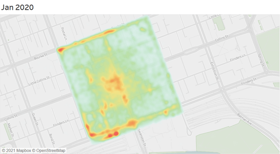
Altometer have been turning data into insights across three City of Melbourne locations. This process revealed behaviour patterns and further sites of interest.
The red areas indicate high levels of pedestrian movement (see GIFs below), orange represents moderate pedestrian movement and green represents low pedestrian movement. Select the GIFs to see movement data animation.
The project team analysed the data and considered other factors including lockdown periods and physical landmarks in order to select the next three key focus sites for this project.
Three sites were selected from this phase. They demonstrated moderate pedestrian activity (orange colour) and the physical spaces exhibited potential for exploration and testing. We also considered things like existing furniture, pedestrian flow, cars and parking, shade, plants and lighting.
Place audits enable insights into how public spaces work at a local level. By capturing stories about how people are engaging with our spaces, we can be better informed to plan, design and maintain them.
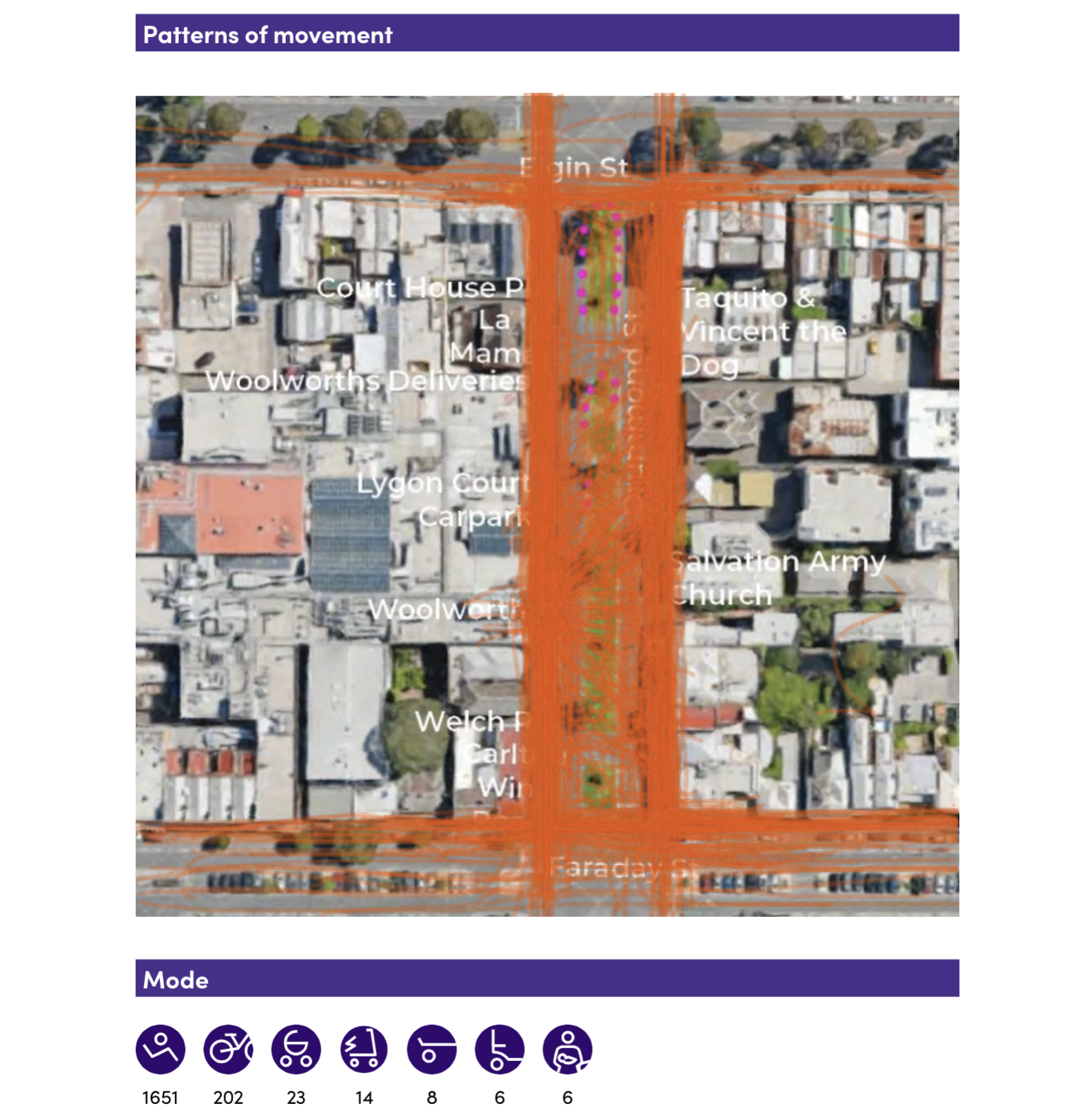
Inhabit Place deployed seven auditors to three sites in Melbourne: Macarthur Square, Drummond Street and Argyle Square to capture observational data.
In one day of auditing, the Drummond Street site was the most popular with 2002 people observed. However, unlike Macarthur Square and Argyle Square, 95 per cent of users were passing through with only five percent spending time in the green median strip.
Key user profiles observed across the sites include:
- Macarthur Square: locals
- Argyle Square: workers on lunch breaks, office meet-up
- Drummond Street: shopper, lounger
When auditors interviewed users, they discovered a variety of insights around how they feel at these sites, as well as what improvements they’d like to see here.
The following criteria were applied to determine the final site for the new furniture:
- Is there enough pedestrian activity to test an intervention?
- Did users demonstrate an intention to congregate in the area?
- Does the space provide good opportunities for people to congregate (i.e. enough space, good traffic conditions etc.)?
- Did visitors express other desires or needs during interviews?
- Could the design developed for this site be used for other sites around Melbourne?
Other areas considered in the furniture designs include:
- Transport behaviours and any potential for positive impact
- Existing furniture and the amenity it provides
- Perceptions of safety
- Macro opportunities (i.e. is it a thoroughfare between significant hubs?)
The Drummond Street median in Carlton was determined as the final site.
Get a snapshot of the movement paths in the images below or download our place audits to dive into the data:
All stages of the design process were informed by the data collected in the earlier phases.
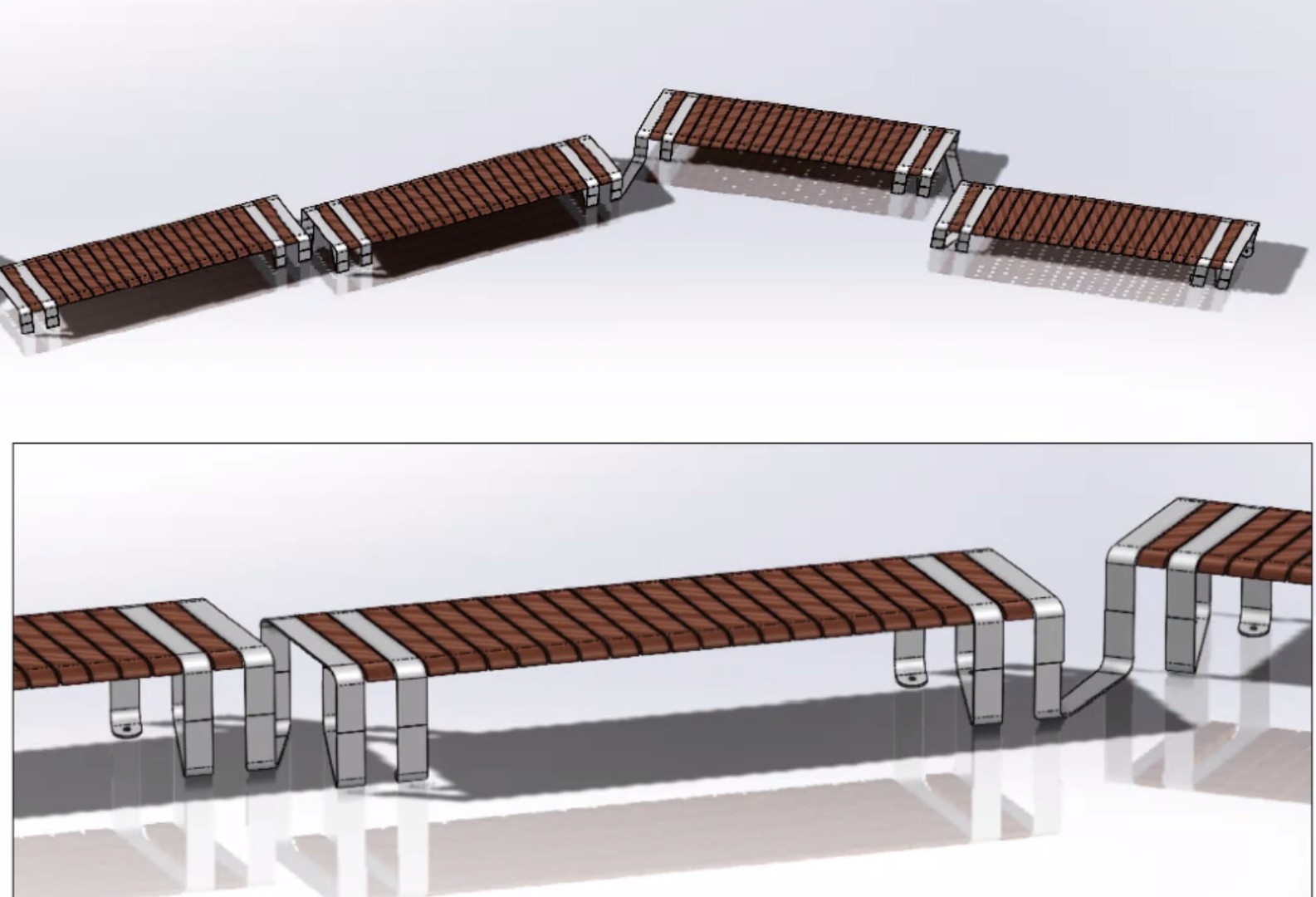
Concept designs demonstrated various ways data could be interpreted into furniture items. See a snapshot of concepts below. Several collaborative workshops developed the data and concepts into a final design.
The following points show how data led to seven design intentions and the outcomes that you can see in the final design. The final design is approximately seven meters long, two and a half meters wide and two meters high. It is constructed from Australian hardwood timber (spotted gum) with an oil finish with a structure made from powder coated galvanised mild steel. Designers considered tree locations, future planting and sprinklers.
See some of the concept designs in the images below.
Design intention 1: Enabling a bustling ‘social space’
Through conversations we learned that users wanted items that can enable busking, live performance or other activations. The design contains a small 'stage' area as well a variety of different places for people to dwell and invite social activation.
Design intention 2: More places to sit and eat
People expressed a desire for more seats and tables for picnicking and “enjoying the outdoors”, to “enliven the space” and provide options for older groups who found sitting on grass inconvenient. Top observed behaviours were dwelling (52%) and eating or drinking (44%) with people sitting on the grass (sun and shade), in nearby alcoves and event leaning on bike racks.
In the design, there are several different places to sit, eat or drink across four distinct features: stage, high bench, double open seat and seat with armrest.
Design intention 3: Safe and share-able
People expressed a desire for furniture that enabled people to maintain social distance. A long design (seven metres) allows users to maintain social distancing. The spine of the design provides some privacy between the two sides while maintaining visual connections through the perforations.
Design intention 4: Efficient and useful
The design can accommodate the following activities at the same time: a person can be sitting on their own eating a picnic lunch, children could be playing on the adjacent stage, friends could be catching up on the other side of the chair, with a couple of colleagues standing and using the ledge to eat lunch and catch-up. This efficient and useful design responds to user feedback that the space feels underwhelming, underutilised and segregated.
Design intention 5: Supporting diversity
Diverse activities included work breaks (uniformed users), family outings, leisure and exercise, dog-walking, grocery shopping, hospitality patrons and more contributed to a sense of ‘buzzing’.
The design expresses and hopes to support this diversity through an interesting asymmetrical form.
Design intention 6: Open and inviting to complement existing pedestrian flow
Audits noted that both sides of the street are heavily used, that the Lygon Court Woolworths entrance was a key feature movement corridor and all along the median was used a lot as a crossing point. A multi-directional design with many ‘faces’ invites users approaching from different directions and complements existing movement paths to feel organic.
Design intention 7: Support safe transport, transitions and waiting
A mix of transport modes were observed including cars, taxis, rideshare vehicles, scooters, bikes, prams, skateboards and e-scooters. With cars entering covered parking, Ubers and rideshares dropping-off and picking-up and bikes and scooters being locked or parked the space felt like a transport hub. Very few pedestrians waited for traffic lights to indicate green for crossing. The design faces out so that anyone dwelling might be aware of surrounding traffic flow. An urban dance floor or handball court, for instance, would not have been a good fit for the dynamic nature of the space.
The following design principles also guided designers.
- Comfort: The design includes comfortable seating surfaces, giving people the option of an armrest or open seat and includes wooden slanted backrests for comfortable dwelling. Materials were chosen for comfort, with steel as the structural material and timber for contactable areas.
- Accessibility: The surrounding slab under the chair was designed with a larger circulation space on the side with an accessible ramp nearby, to accommodate a wheelchair user. Someone with a walker, pram or trolley might also find this space useful.
- Enhance the character and create a sense of place: The chair is natural timber with powder coated steel in 'Leaf Green' to reference the existing urban environment. An artistic form could improve the usefulness of the space while adding to its character - “meet you at the wavy chair!”.
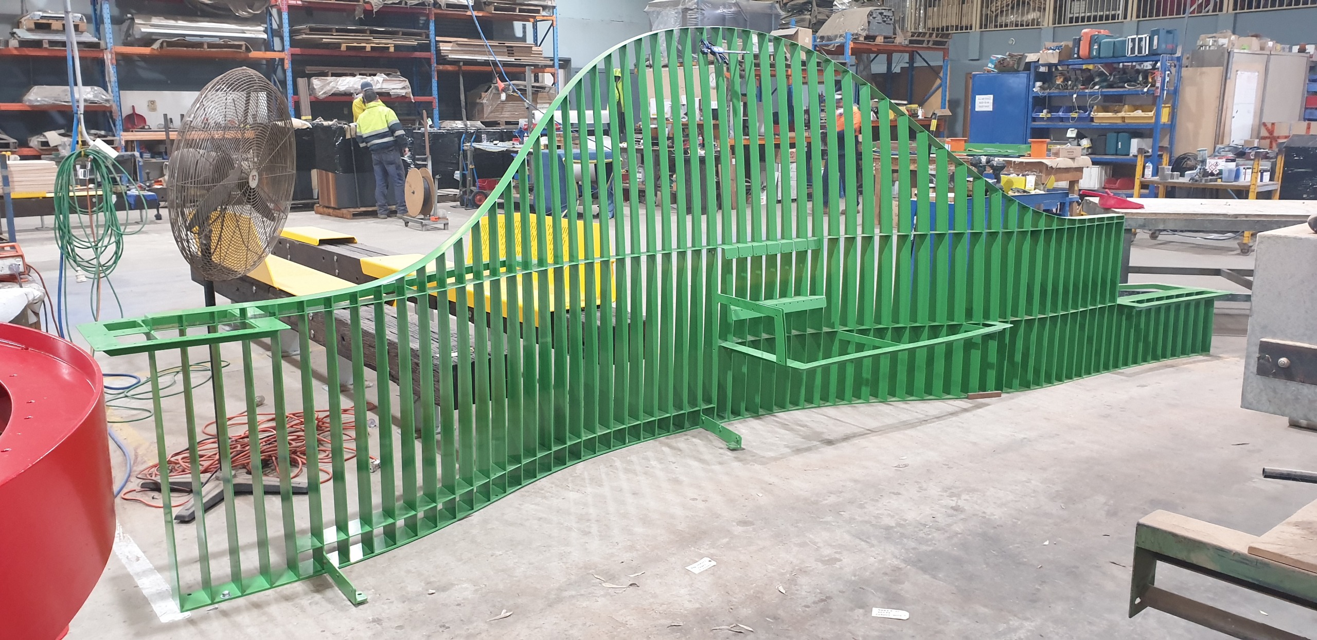
The design is currently being manufactured in Adelaide by Rowlands Metalworks, overseen by designers at Spark Furniture. See a snapshot of the manufacture process below. It will be installed in December 2022.
Data has been collected through a variety of methods over the last eight months to better understand the impact of the design. We are analysing data collected through sensors, mobile phones, observations, online and in person surveys, and community feedback.
In April and May 2023, we conducted two place audits to capture observational data. We compared these with the place audit undertaken in November 2021 to better understand how community behaviour has changed since the design was installed.
Users said the design is efficient and useful due to the different areas available to sit, including more private aspects of the structure. They also liked the innovative design and atmosphere around the space. Many respondents said they would like to see more seating in the area.
Through place audits, we have learnt this area in the median strip has been increasingly occupied and used more, while familiarity of the area also increased. The space is being used more equally by diverse users of the community in different ways, improving inclusivity of the area , and enhancing social activities such as conversations between strangers.
However, not all insights were positive. Some respondents were concerned about the maintenance of the space. We are addressing these concerns and reviewing current maintenance schedules.
Sensor data shows the design has had four times the use of the existing metal bench nearby, almost seven thousand uses compared to 1,700.
We used mobile phone data from before and after the chair was installed to better understand pedestrian activity in the area. There is more than four times the activity here than the same period in previous years. This suggests the chair has positively impacted the social atmosphere of the space, with a innovative and responsive design.
View the live dashboard to see sensors in action and data collected.
The data and insights will determine the future of the chair and whether it will be left as is, improved or moved. Stay tuned for an update in October.
Phase one: Pedestrian movement data for Carlton North in 2020 and 2021. Red indicates high movement, orange is moderate and green is low.


Phase two: Place auditors document demographics, mode of transport, movement patterns, obstacles and more. This is a snapshot of Macarthur Square.


Phase three: Concept designs varied greatly but were consistent in adding more seating and enabling different group sizes to dwell in the median.
Phase three: A design that used organic forms and created a unique character was chosen to be developed further using the data.

Phase three: The final design was developed collaboratively with designers and the pilot team, responding to data in the ways outlined above.

Phase four: The chair during manufacture, showing the galvanised mild steel before it was painted green.

Phase four: The chair is natural timber with powdercoated steel in 'Leaf Green' to reference the existing urban environment.

The technology
- Digital Matter Yabby Edge - accelerometer
- VivaCity Artificial Intelligence Road Survey sensor (AIRS) - pedestrian and bike sensor
- Usage of the existing bench in the median strip
- Most popular times of use for the new design
- How people are moving around the new design
- Popular modes of transport in this area
- Key movement pathways
- Speed of movement of bikes and pedestrians at various times.
Data from the Yabby Edge sensor on the existing bench is collected to help us understand how people use this seat. This will help us to understand how people use the existing chair in comparison to the Social Spaces design which will inform future planning and design. These sensors are also used in Argyle Square, Royal Park and at Micro-Labs. You can see some of the data captured by this type of sensor on our public dashboards for Micro-Labs and Argyle Square.
We will also collect data using an AIRS sensor to understand the flow of people around the design and their transport modes. For instance, it will be able to tell us the busiest times, most popular modes of transport and the kinds of movement around the design. We have also installed this type of sensor at Southbank Promenade to learn more about how people use different modes of transport in this busy city thoroughfare.
Data will also be collected via observational audits in 2023.
Yabby Edge sensors use low power wide area networks or LoRaWAN to transmit the data. The VivaCity AIRS sensor uses 4G networks to send data. The data is sent to City of Melbourne’s data lake in AWS Australia.
The data is used by City of Melbourne to measure the impacts of the Social Spaces design and inform how we plan and design other outdoor spaces like this. The data will be shared with the community via a dashboard on this page soon.
This data will be stored permanently for any possible future analysis.
For the AIRS sensor, no video footage is stored or transmitted. The only data that is stored is created from analysis of the footage.
Question forum
Have a question about the Social Spaces project? Ask our Emerging Technology Testbed team and get answers.
To ask a question you must create an account or log in.
These are the people that are listening and responding to your questions.
Emerging Technology Testbed
{{question.description}}


